"Don't be evil"
Tuesday, 12 August 2008 08:35 pmThat is the slogan used by Google.
Are they living up to it? We all remember how they bowed immediately to censorship in China. That was a big disappointment.
Now Georgia has disappeared* from GoogleMaps.
[*I've since been told Georgia was never on GoogleMaps, but this is no less puzzling than a recent disappearance would be. Maps of that region have been available for decades. What possible reason would there be for omitting such a world trouble-spot?]
http://twxr.us/1a5
or see on GoogleMaps itself:
http://maps.google.com/maps?f=q&hl=en&geocode=&q=&ie=UTF8&ll=41.926803,44.648438&spn=4.119432,7.349854&z=7
Bummer.
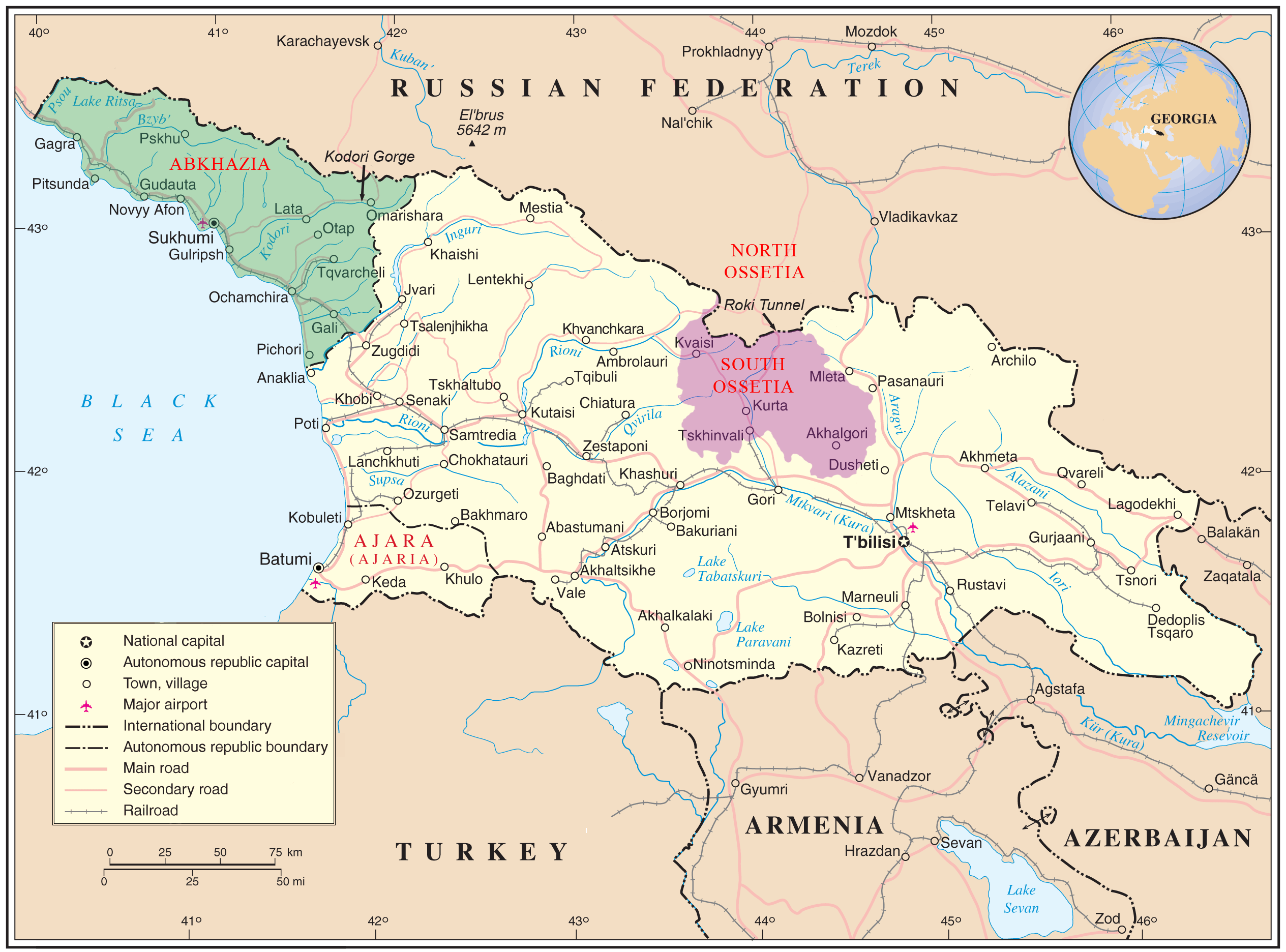
Additional: There is a very nice 2,529 x 1,872 map on Wikipedia at
http://upload.wikimedia.org/wikipedia/commons/9/91/Georgia_high_detail_map.png
in the article there on Georgia
http://en.wikipedia.org/wiki/Georgia_(country)
Are they living up to it? We all remember how they bowed immediately to censorship in China. That was a big disappointment.
Now Georgia has disappeared* from GoogleMaps.
[*I've since been told Georgia was never on GoogleMaps, but this is no less puzzling than a recent disappearance would be. Maps of that region have been available for decades. What possible reason would there be for omitting such a world trouble-spot?]
http://twxr.us/1a5
or see on GoogleMaps itself:
http://maps.google.com/maps?f=q&hl=en&geocode=&q=&ie=UTF8&ll=41.926803,44.648438&spn=4.119432,7.349854&z=7
Bummer.
Additional: There is a very nice 2,529 x 1,872 map on Wikipedia at
http://upload.wikimedia.org/wikipedia/commons/9/91/Georgia_high_detail_map.png
in the article there on Georgia
http://en.wikipedia.org/wiki/Georgia_(country)
no subject
Date: 2008-08-12 01:05 pm (UTC)It is just becoming evil.
And when you're evil, evil is good.
Of course, I can see Georgia on the Google Maps link, but not any sign of the two "breakway provinces". It's still there on sat-view as well.
The optimist in me has decided to believe that the layer which has been removed is missing so that people can't use Google Maps to target bombs and stuff. IIRC you are on dial-up, so neither of us can check Google Earth - but I can say that in sat-view there are some really weird processing anomalies - like large white smears - reflections perhaps?
no subject
Date: 2008-08-12 01:27 pm (UTC)no subject
Date: 2008-08-12 02:05 pm (UTC)Not to my eyes, I have seen clouds before, which is why I thought they might be flares off metal constructions. At the speed the sats are travelling... maybe.
Am I the only one who thought Georgia looked more poked than a 14-year-old boy's face?
That happens, perhaps at the Government's request, perhaps because it doesn't load properly.
The two other nations east of Georgia are lacking in details too, so I think it's too early to call this a conspiracy.
no subject
Date: 2008-08-12 02:16 pm (UTC)The military would not need GoogleMaps. They have their own maps. Only the civilians would really be need it. Those inside the defaced country might be trying to escape or work out where the threats are. Those outside would be trying to understand what is going on inside.
no subject
Date: 2008-08-12 02:39 pm (UTC)Gawsh... Cynical? More than me?
Civilians would, in all likelihood, know how to get out, either by UBD or physical maps. I doubt the vast population of Georgia use GoogleMaps while driving (does anyone?), and if they do use similar they would have GPSen such as TomTom. Or they could just follow the sun.
Those outside would be trying to understand what is going on inside.
Given the frequency at which Google updates its maps, they would be less than useful.
no subject
Date: 2008-08-12 10:06 pm (UTC)Also, I tend to examine online maps rather than rely on outdated paper maps, then download them to my little Palm computer and use it. When Mum & Dad recently had to visit a doctor in a part of Brisbane that they were unfamiliar with I printed out some online maps for them to use.
From what I've heard, I'm not alone in this. Online maps are heavily used by civilians. I don't imagine the military would need them. I've seen the kind of maps that the Australian Army use. They are incredibly detailed.
If you wanted to get out of Australia and you were unable to leave via Perth or Fremantle, would you attempt to look up online maps for other airports or seaports? You, like me, love books so there is a chance you have that information on paper, but most people don't, outside their local area.
Given the frequency at which Google updates its maps, they would be less than useful.
If they were looking for some view of the action, yes. But that isn't what people view maps for, generally. It is to find out where exactly in Georgia Tblisi is or Sukhumi is when the news mentions such places. Interestingly such place coordinates are contained in GoogleMaps so you can search for them if you have the correct spelling, but the lack of annotations would make life difficult for civilians.
no subject
Date: 2008-08-12 11:18 pm (UTC)Oh, I do that - but usually my UBD (unless it's somwhere for work, then I print out the map from Whereis.com.au so I don't have to brave the traffic, find a parking spot and then find I'm at the wrong end of the street.)
Given the general lack of roads out of Perth, and the number of ports/airports, I probably wouldn't need to - but I take youer point.
no subject
Date: 2008-08-12 01:23 pm (UTC)It is perhaps, as
I'll have to check Google Earth and see the satellite maps, too. Satellite images may either be old or censored in order to avoid civilian snooping or snooping by other countries' intelligence agencies.
Edit: Apparently Armenia and Azerbaijan no longer have roads, mountains and rivers, either!
no subject
Date: 2008-08-12 03:26 pm (UTC)I've been following Georgia for years, and always been frustrated by this. But nothing has changed in the last week.
plz check facts before accusing kthxbai
no subject
Date: 2008-08-12 09:35 pm (UTC)But I find this extremely surprising. Why would they not have maps of Georgia? It seems to me that it would not be terribly difficult to obtain maps of Georgia. I have old world atlases on paper that have roads and cities mapped inside Georgia, Armenia, etc.
You point up an interesting problem of the internet: exactly how would one check whether something used to be on the internet. Please note that I'm not disagreeing with you. I would have loved to check whether the images had recently evaporated, but the ephemeral nature of the net makes this pretty-much impossible.
I have in the past managed to use the Internet Archive Project to dredge up data that the Australian government deleted from their sites (in particular a study into relative costs of different forms of energy) when their (corrupt) aims didn't fit reality. So sometimes you can verify that something has been removed from the net. But GoogleMaps blocks the InternetArchive bots (I've checked) so no history is visible. There are perfectly legitimate reasons to block archiving bots, bandwidth limitations being the main one.
And that brings up yet another question: how responsible is it of our civilisation to rely on ephemeral information sources that can be so easily controlled and manipulated? For instance I love the Wikipedia project, but it all lives on centralised servers. That is very unsafe.
no subject
Date: 2008-08-13 01:52 am (UTC)A lot of less-developed countries have only major highways marked (try Afghanistan and Zimbabwe), and I'm pretty sure I've seen other countries with nothing at all.
no subject
Date: 2008-08-13 09:49 am (UTC)no subject
Date: 2008-08-14 11:20 pm (UTC)http://upload.wikimedia.org/wikipedia/commons/9/91/Georgia_high_detail_map.png
in their article on Georgia (http://en.wikipedia.org/wiki/Georgia_(country))
no subject
Date: 2008-08-13 03:39 pm (UTC)no subject
Date: 2008-08-14 11:09 pm (UTC)The first thing I think of when I hear of Georgia is the Beatles' song "Back in the USSR", so our culture has far reaching effects on us all. Georgia existed many decades before the Beatles mentioned it only a couple of times in the chorus, but that song is what my mind zeros in on.
Looking on Wikipedia, Georgia is a beautiful place. Agriculture and tourism are their two big money earners. I bet they are regretting the oil pipeline and the gas pipeline through their country that seem to have brought the Russians invading. I don't think it will have helped their tourist industry much. Poor Georgians.